Western Arthurs
A serrated quartzite range above the tarns of Tasmania's south-west
- Region
- Southwest National Park
- Length
- ~58 km loop
- Duration
- 5–7 days
- Grade
- Grade 5 (very experienced)
- Daily departures
- 12 max
- Registration
- Required (free, PWS)
Track booked out?

About the traverse
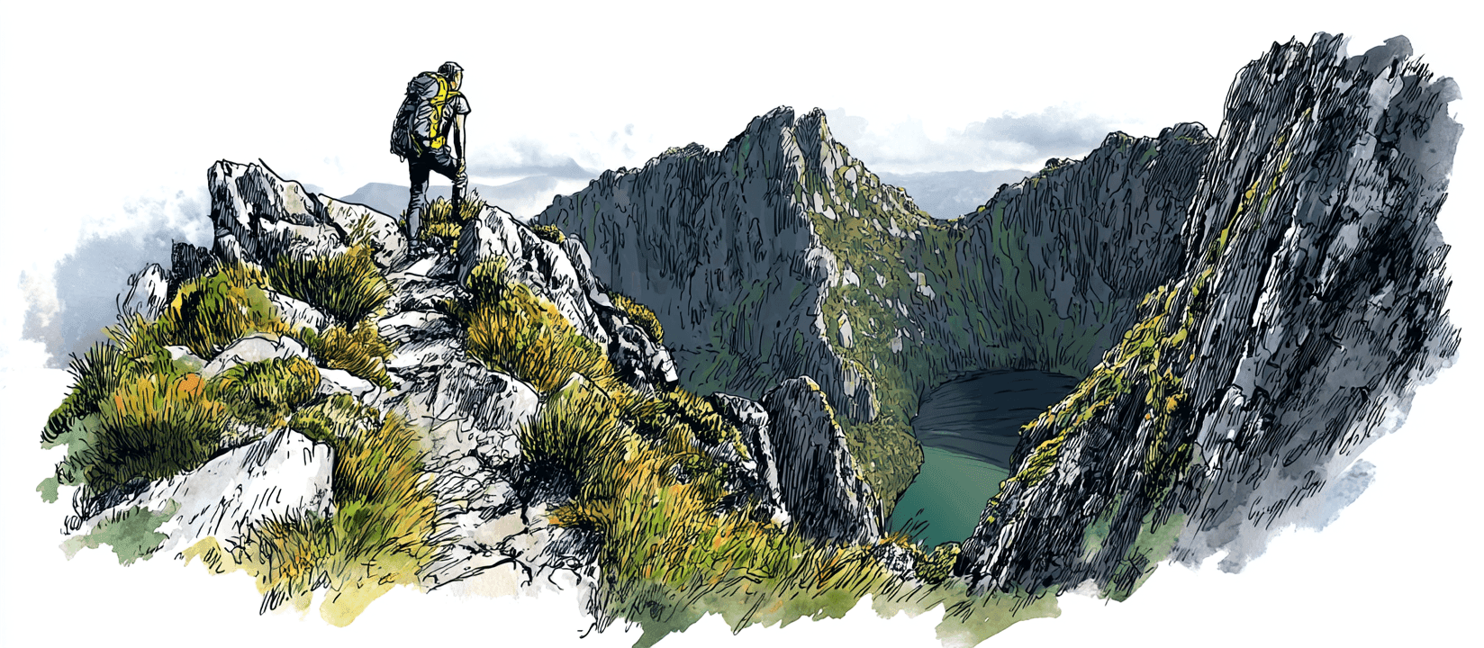
The Western Arthur Range Traverse (the WART) is, by common agreement, one of the most demanding multi-day bushwalks in Australia. The range is a single serrated wall of pale quartzite thrown up above the buttongrass plains of Tasmania's south-west: 21 peaks over 1,000 metres, strung together by a route that climbs, drops, and scrambles its way along the crest for days at a time. Glacial tarns sit in the cirques between the peaks, and the camps beside them (Lake Cygnus, Lake Oberon, High Moor, Haven Lake) are among the most spectacular in the country.
This is a Grade 5 walk: rough, steep, frequently unmarked, with serious exposure, rock scrambling, and pack-hauling on the harder pitches. It is for very experienced parties only, confident with map and compass in poor visibility and self-sufficient for a week in genuine wilderness. The full loop is around 58 km over 5 to 7 days, but distance tells you little here: progress is measured in the weather and the terrain, and a single bad day on the tops can pin a party in camp.
Registration and the booking situation
Every overnight walker on the Western Arthurs must hold a Parks and Wildlife Service walker registration for their start date. Registration is free, but it is not unlimited: the booking system caps each departure date at a maximum of 12 walkers, and you register for a specific start date and party size. It exists for walker safety and to keep numbers sustainable on a fragile alpine route.
Twelve places a day is not many. The walking window is narrow, the good-weather spells are few, and a settled summer forecast, or a long weekend, can push a popular start date up to its cap. When that happens, your date shows as full and you're left refreshing the page hoping someone drops out.
And they do drop out. The Western Arthurs is a serious commitment, and plans change constantly: forecasts turn, parties lose a member, trips get deferred to next season. Places quietly free up as a date approaches. The trouble is that a freed place is taken by whoever happens to be looking at that moment.
That's what Spotbagger watches for. We check the PWS walker registration page for the Western Arthurs every few minutes and alert you the moment a date you want has room for your whole party, so you can register before the place is gone again.
Seasons and conditions
The usual season is summer and early autumn (December to April), when the days are longest and the tops are most often clear. Even then, the south-west is one of the wettest, most exposed places in Australia: rain, gale-force wind, cloud, and snow are all possible on the range at any time of year, and the quartzite turns lethally slick when wet.
The range gives you almost nowhere to hide. The ridge sections between the tarns are committing (once you're on the crest, retreat can be as hard as going on), so the weather dictates everything. Most parties build spare days into the trip and simply wait at a tarn camp for a front to pass rather than push exposed ground in cloud. Outside the main season this becomes a full alpine undertaking and is for expert, well-equipped parties only.
Camps and water
There are no huts on the Western Arthurs: every night is a tent night, and your shelter is what you carry. The classic camps are the alpine tarns along the range: Lake Cygnus and Lake Oberon on the way in, High Moor and Haven Lake deeper along the crest, with Junction Creek on the buttongrass plain at either end of the traverse. Pads are limited and exposed; pegs hold poorly in the thin alpine soil, so carry good guys and be ready to weight your tent with rock.
Water comes from the tarns and creeks and is generally reliable in season, but the high camps are fragile: keep well back from the water's edge, use the provided toilets or pack out where there are none, and tread the established pads to protect the cushion-plant and moss. Fuel stoves only; there is no firewood and fires are not permitted.
Gear essentials
This is exposed alpine Tasmania, where the weather does the testing and there is no bail-out. The short list:
- Rain jacket and overtrousers: genuinely waterproof hard-shell, not water-resistant
- Four-season tent: huts don't exist here; your shelter must take wind and rain on an exposed pad
- Warm layers: fleece or down, plus hat and gloves, even in summer
- Sleeping bag and mat: rated for cold, wet alpine nights
- Stove and fuel: no fires, no firewood; carry enough for the whole trip
- Sturdy boots and gaiters: for wet quartzite, scrambling, and the muddy plains
- Map, compass and PLB: the track is unmarked and there is no phone coverage; carry them and know how to use them
PWS publish a recommended gear list with the walker registration; read it before you finalise your pack.
Getting there
The traverse begins from the Scotts Peak Dam Road in the Southwest National Park. Most parties start at the Huon Campground / Scotts Peak trailhead, roughly a 2.5-hour drive from Hobart via Maydena and the Gordon River Road. There is no public transport to the trailhead, so walkers self-drive and leave a vehicle for the duration, or arrange a private shuttle from Hobart.
From the trailhead the Port Davey Track crosses the buttongrass plains to Junction Creek before the route turns up onto the range; the loop returns the same way. You'll also need a Tasmanian parks pass for the national park (separate from the free walker registration). Lock in your start date and your registration as soon as your plans and a settled forecast line up; with only 12 places a day, the good dates are the first to reach their cap.
Common questions
Do I need to book the Western Arthurs?
Yes. Every overnight walker needs a PWS walker registration for a specific start date and party size. Registration is free, but each departure date is capped at 12 walkers. You'll also need a Tasmanian parks pass.
My start date is full. Can I still get a place?
Often, yes. The traverse is a serious commitment and plans change constantly: forecasts turn, parties shrink, trips get deferred. Places quietly free up as a date approaches. Set up a watch and we'll alert you the moment your date has room for your whole party.
Are there huts on the traverse?
No. Every night is a tent night at the alpine tarn camps (Lake Cygnus, Lake Oberon, High Moor, Haven Lake). Carry a four-season tent and be ready to weight it with rock; pegs hold poorly in the thin soil.
How hard is it really?
Grade 5: rough, steep, frequently unmarked, with real exposure, rock scrambling, and pack-hauling on the harder pitches. It's for very experienced parties who can navigate in poor visibility and stay self-sufficient for a week.
Other tracks we watch
Overland Track
Cradle Mountain–Lake St Clair National Park, Tasmania, Australia
Milford Track
Fiordland National Park, Southland, New Zealand
Routeburn Track
Mount Aspiring & Fiordland National Parks, Otago & Southland, New Zealand
Kepler Track
Fiordland National Park, Southland, New Zealand
Heaphy Track
Kahurangi National Park, Nelson Tasman & West Coast, New Zealand
Hollyford Track
Fiordland National Park, Southland, New Zealand
Frenchmans Cap
Franklin–Gordon Wild Rivers National Park, Tasmania, Australia
Can't get a booking?
We'll watch for you.
Spotbagger checks the Western Arthurs booking page every few minutes. The moment a spot opens, we'll tell you.